Back to Main
Cesky Raj Certoryje Events Page
Cesky Raj Maps
Below are some scanned in maps of the region. You can click on
any of these maps to see it in greater detail. In MS Internet browser, double
click on the map and press the icon to be able to zoom in on the map. Or right click it to either
download it to your computer, or to open it in another window so as to compare
these maps against the Cesky Raj bus route and schedule (again,
right click to select Open in New Window if you want to compare easily).
| I put little pink dots on trails where I know it is very
beautiful. I will try to go to Jicin (bottom right map) this weekend to check
out the path heavy section to it northwest (and update that map later).
If you would like to print out the larger version of these
maps and the 700KB JPG quality is not good enough (the ones you download when
you click on the maps below), I also have the much larger BMP versions. In any
case, I will try to find someone with a quality colour printer to print out
quality versions for all of you once you get here.
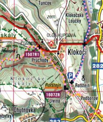
Right you see a closeup
of the pink dots (here, along the blue and yellow marked trails) I drew on the
maps, showing sections I think are particularly nice. Notice the restaurant with
delicious beer the path strategically swings by in the bottom right hand corner.
[For those who are not familiar with marked trails in Czech forests, the
markings are painted on trees. Usually three colour horizontal stripes, the
colour on the outside two, with a white strip in the middle. These my favourite
maps can be purchased from
ShowCart.]
|
 |
Below you will find an explanation of the trails I picked out,
with a link to the pictures on this website.
Click on the maps below to view them in greater detail (right click to download
to your computer).
Friday:
Bottom left map (Certoryje/Hruba
Skala)
Get into the campsite from Jicin either by local bus or by
hired bus. I would suggest that people already be dressed for running. If taking
the local bus, someone can come with a van and pick up all the luggage and drop
it off either at the camp or to the hotel. I would suggest that for today's
trail go south from the camp along the green path (you should be able to see
small pink dots on the map showing the routes I am proposing), southwest to the
red path, and then southeast along the red. Near the beginning of this red path,
keep your eyes out on your left hand side, as there is some tasty spring water
you can fill into a plastic bottle or something!!
You eventually get to Nebakov (where we can have a quick beer
stop if people like) and the goal is to head north east towards the Trosky
castle ruins. To do this, you can either go up along the blue, green or red.
Perhaps the faster runners can go up along the red and the walkers along the
blue.
All these eventually hook up together before Trosky. Have a
stop and check out Trosky and then continue along the blue to Borek. Maybe quick
beer stop there.
From Borek head southwest along the yellow, along the lakes
back to the campground. Suggest a beer/snack stop at Vidlak, half way to the
camp, as they cook rather good here. Perhaps just Garlic soup (chesnechka), to
save your tummy for the roasting pig!
Continue to the camp, and perhaps take a dip in the lake just
to its south.
Alternatively, for the walking snails, they can go northwest
along the red from Trosky, straight to Vidlak. I can take additional detours for
the fast runners and all this can be arranged that day (live hair) based on
demand and requests.
For those who come later in the day, they can phone me on my
mobile (numbers on entrance webpage) to find out where we are, and try to hook
up with us.
Saturday:
Top right map (Mala Skala)
Mala Skala itself is great, and if it
happens to be really hot, you can have a fantastic swim down the weir in the
river. There are also lot's of cool pubs. Across the river along the blue (not a
fantastic walk), you will eventually run into Drabovna, where a castle once
stood on the cliffs. First six pictures
here.
If you have the time, you can head back along the red and go north to Frydstejn
(not a fantastic walk -
picture), check out the Frydstejn castle and then continue back towards the
Vranov Pantheon castle (8 pictures following
here). Perhaps the runners will want to do this leg as well.
Across the river on the same
side as most of the town (south side) is a fanTAStic walk, and hence why we want to
save this
for Saturday (16 pictures following here).
Half way through that walk, at the pink number 1410R1, you will find a pub (note
the picture of a half litre of beer on the map) which is perhaps our second favourite.
Picture here.
From there we can complete the yellow, if desired, and then
continue south east along the red until Koberovy, where we switch to the blue
heading south until Rotstejn. From there we can go southeast along the yellow
for a snack and beers at Podluktusi.
From there go up to Rotstejn, and continue along the yellow, eventually heading west
along the yellow towards Mirova pod Kozakovem (direction back to Turnov). On the
way to Mirova there is a place called Mala Amerika (Small America - if I remember correctly),
which is a maze of caves and large caverns. Didn't get a chance to check that
out yet but heard it was fantastic. Before heading southwest along the yellow,
you may want to continue walking along the ridge along the red for a bit
(heading northwest), and then head back to hit the yellow again.
Sunday:
Top left map (Krasna Vhylidka)
Renting a bus for all of us, which will leave early morning,
take us for a beer break at the Kost castle, and then to Branzez where we
walk/jog along the pink dotted trail eventually to the Valecov castle. Then the
bus will take those going back to Prague to Mnichovo Hradiste, where you can
catch the train leaving from Turnov at 18:15.
To repeat, from Branzez we can walk north along the yellow (pink dots on
map) to Prihrazy (first
four pictures here), a bit above the lake
in the centre of the map, and go up (northwest) the red trail to Krasna Vyhlidka
(Beautiful View), where they cook fairly well and where you can stop for lunch.
Picture sample.
Then continue along the red to the
various castles. Picture samples
here,
here and
here.
Once you get to the last castle/ruin (Klamorna),
you can continue along the red (not as nice) and end up in one of our favourite
pubs, nestled into the Valecov castle. First seven pictures at top of page
here.
From there get a ride back, or jump on the 17:17 local bus at
Bosen-Zasadka to take us back to Kost at 17:47, walking back to the camp from
there along the green.
On this same map, another worthwhile visit is the
Kost castle, below right/southeast along the red
from the lake in the middle of the map.
Monday:
Bottom right map (NW of Jicin)
In the Stary Hradek area in the centre of the map. To it's
upper right is a nice lake with sandy beach. Costs 40 Kc to get in but well
worth it. Will try to scan in a more detailed map of this particular area and
the trail which was suggested to me. Good restaurant at Turisticka Chata.
Pictures here.
In the morning, a 9:55 bus from Hruba Skala takes us to Holin
Prachov Cesky Raj at 10:38.
Then I would suggest going down to the lake and catch a
yellow bus (or walk) from Jinolice Koupaliste at 17:33, one bus stop to Libun
Brezka at 17:40, from where you can catch a red bus at 18:45, arriving to Hruba
Skala zamek at 19:19. Hopefully I got this right.
Tuesday:
Bottom left map (Certoryje/Hruba
Skala)
This area is close to the campsite and
many people will be staying at the hotel in Hruba Skala, so a Tuesday walk here
would be ideal. Start at the Hruba Skala hotel, dive in along the yellow to the
foot of the pillar formations you overlook from the hotel, and wind through this
maze of beauty, taking careful note to see the various climbing points (maybe
you will see a lot of climbers). That eventually takes you to Valdstejn castle,
where you can have a quick snack, to head back along the ridge and blue (picture
here), back to Hruba Skala.
Those who want to continue on to Turnov to head back to
Prague can continue northwest along the red trail. Unfortunately, the train
station you need to get to is not on this map, so refer to the Mala Skala map
(top right above). You would continue along the red until you hit the yellow, at
which you would head west to cross the river. The yellow should take you right
to the main train station (the little white square on the rail line by the green
info circle).
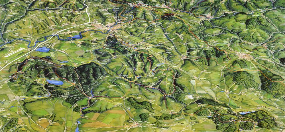
Here is a 3D map of the area, which you can see a larger image
of by following the instructions in the top paragraph.

World Languages | Link Exchange
Czech to English Translations Translator |
Czech Republic |
My Life in Prague |
Czech Festivals |
My Reflections of the Czech Republic


